
Geologic Tour of the Crypt Lake Trail - Waterton National Park, Alberta
The Geologic Story of Crypt Lake and Waterton Lakes:
Follow through the story of the formation of the landscape visible today along the Crypt Lake trail.
The Geologic Time Scale:

The Ancient Sediments:
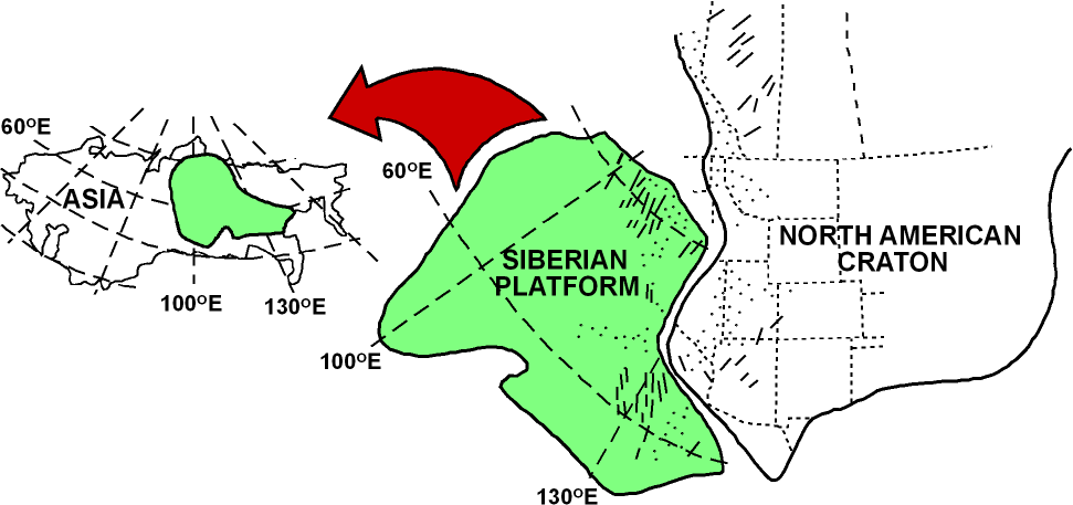
During the middle Proterozoic (1.5-1.4 Ga) the Siberian Platform was rifting away from the North American craton (also known as Laurentia) and the supercontinent Columbia. Inbetween these two crustal plates formed a rift basin, which filled with water, forming a shallow inland sea. This basin rapidly infilled with sediments, accumulating beds up to ten miles thick in less than 100 million years. Basin formation between two tectonic plates thins the Earths crust, allowing for magma from within the Earth to rise to the surface forming basalt flows, sills, and dikes. These igneous intrusions outcrop in other parts of Waterton but are not found along the Crypt Lake Trail. Sea level rise and fall within the basin left record in the sediments in the form of turbidite beds during deep water depostion, ripple marks during shallow water deposition, and mud cracks during tidal deposition. Stromatolites, ancient cyanobacteria mats, formed round sedimentary skeletons along the seafloor in warm-shallow seas, which can be found the basins limestone deposits. The immense beds of organic matter, sands, muds, and silts were eventually buried, laying dormant for hundreds of millions of years underneath a passive margin. Here they were buried deep enough to only be slighty metamorphosed, transforming the now lithified sandstones, limestones, and mudstones into argillites and quartzites. This massive sedimentary package is known as the Purcell Supergroup, or Belt Supergroup in America, and composes the exposed rock found in Glacier and Waterton-Lakes National Parks. The rocks, however, did not form in this area, which leads us to the next segment of our story.
Depositional Area of the Purcell Supergroup:

The Current Position of Exposed Purcell Supergroup Rock:

The North American and Siberian Platform Rift (1.5 Ga):
Follow the Link to Get Up Close and Personal With a Stromatolite found on the Crypt Lake Trail:

Riding the Terrane Train:
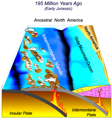
During the early Jurassic (200 Ma) the North American West Coast became quite active with the arrival of the Intermontane Superterrane. After the breakup of the supercontinent Pangea, the continent began to drift North-Westward, subducting dense oceanic crust underneath its margin. This set the continent on a collision course with large island chains riding the Pacific Plate that were composed of lightweight volcanic rock. Instead of being subducted with the rest of the oceanic crust, the island arcs smashed into the coastline, accreting themselves onto the crustal margin. These accretions are called terranes, a superterrane is defined as composite terrane assemblages that share a distinct tectonic history. When the Intermontane Superterrane docked with North America, it caused regional deformation and metamorphism of the rock closest to the coast, and shoved rock farther from the coast North East. The arrival of the Insular Montane and subduction of the Farallon Plate in the Cretacious (100 ma) was responsible for the Lewis Overthrust and thus the mountains of Waterton Lakes, and is still being accreted to North Americas coast today. Imagine pushing on one end of a rug and watching the far end of the rug buckle over on itself, then imagine pushing that same rug on a slick surface. This thrusting is how the Purcell Supergroup came to rest in Waterton Lakes, shoved up on top of the slick Cretacious shales and riding them 100 km (63 mi) North-East to thier present position. While the sheet stayed (for the most part), folding and faulting still occured and is visible in exposures along the Crypt Lake Trail. Read on to find out how the overlying strata has been eroded away from the top of the thrust sheet containing the Purcell Supergroup, leaving behind the beautiful mountains we see today.
Cross Section of the Lewis Thrust Sheet:

Folds Present in the Alytn Limestones Found by the Burnt Rock Falls:

Geologist Sean Barnett Examining Faulting Along the Crypt Lake Trail:

Erosion Never Takes a Day Off:
After the tectonic events pushed the ancient Purcell Supergroup to thier current position the area probably resembled a massive plateu that loomed over the plains to the East, but even during the thrusting of the massive sheet of rock erosion was working its way through the rock. This erosion can occur chemically by the solution of rock by acidic rainwater and physically by processes such as frost wedging. Ice, wind, and water are the primary forces that create a landscape, although water and wind are the primary culprits in our story. The current landscape is a result of four major glaciations that occured during the Quaternary Period (2.5 Ma) until quite recently (14 Ta). There are two types of glaciation, cordillarian (originating from mountain ranges) and continental (regional ice sheets). The Waterton-Lakes area was carved primarily by cordillarian glaciers originating in the Rockies that moved North through Waterton valley, while the Laurentide Ice Sheet affected only the Northernmost edge of the park. Glaciers have massive erosive power due to their sheer weight, the rock they carry under them as they flow, and the fact that they are always moving, acting much like a conveyor belt of ice and rock. As glaciers advance, they carve out deep, through like valleys, called U-shaped valleys, much like the one in the upper Hellroaring Creek Valley and the valley containing the Waterton Lakes. As glaciers retreat they leave moraines, kames, and eskers while opening the door for alluvial processes such as waterfalls and alluvial fans, much like the one that the town of Waterton is built upon. There are no glaciers left in the area around Waterton, but erosion is still occuring in the rivers and on the mountainsides; the landscape constantly changes, and so this story will continue long after there is anyone to tell it.
A Series of Cross Sections Displaying the Accretion of the Superterranes:


Diagrams Depicting Glacial and Post Glacial Landforms:


Burnt Rock Falls is a Gorgeous Example of Erosion at Work:

A Great Example of a U-Shaped Valley and Hanging Valley Along the Trail:

Google Earth Image Showing the Waterton Alluvial Fan and the Glacial Topography of the Crypt Lake Trail:
